

What is a rutter?
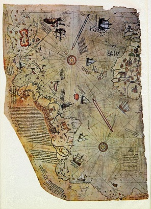
This map is the rutter of Piri Reis, the oldest chart of America seaways in existence. Piri Reis (1465-1554) was a Turkish pirate and admiral. The rutter, drawn on camel skin, is 86cm long and 61cm, tapering to 41cm, wide. (The taper is due to the natural shape of the skin; but the ragged edge indicates that the right hand section of the rutter was torn away.)
Early navigators referred to the precursors to charts that they carried as “rutters.” (The name is likely derived from the French word “routier.”) Rutters were hand-drawn on vellum and combined elements of charts with observations and instructions. Continually updated and revised, they represented the best knowledge at the time and were the navigator’s most prized possession.